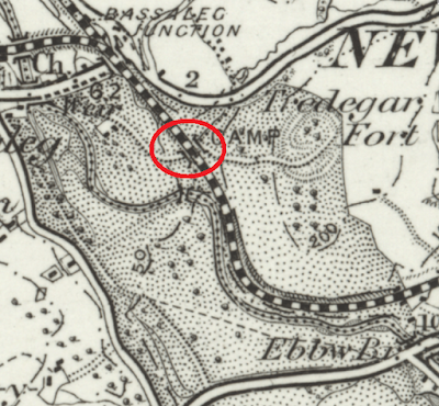
What you will notice (in the red circle) is that there used to be a tunnel under the railway, carrying some sort of path. If you zoom in on the contemporary map you will see that there are still some markings on the ground that suggest it might be still there, and sure enough if you drop the little yellow StreetView man at the end of Golden Mile View you can see it. The footbridge just south of the tunnel that goes over the river is still there, as it happens, and having been closed for a number of years was recently re-opened to provide access between the park and the new housing developments north of the river.
Well, hurrah, you might say, problem solved. Yes, the inter-park access would be better situated at the bottom end of the park, but at least it exists. Trouble is it doesn't, for two reasons: firstly it looks from the StreetView picture as if the tunnel may be fenced off (though it's hard to see), secondly even if you could get there from Golden Mile View the M4 is now in the way of getting there from the Gaer hillfort area.
Golden Mile View, by the way, is so named because of the section of railway which ran through Tredegar Park and was subject to tolls payable to Lord Tredegar, whose land it was, the name being an allusion to the substantial sums his lordship was trousering each time a train ran over the route.


No comments:
Post a Comment