More non-book-related posts, for the love of God, you say? Electric Halibut hears your anguished cries and rides to the rescue on his wingèd steed, entirely naked except for a pair of rather splendid patent-leather riding boots and a dab of Blue Stratos behind the ears.
So, as I mentioned a while back, we moved house during 2022, and of course one of the things that does (unless you've literally moved to the house next door, anyway, which sounds literally insane but which some of our friends literally did a few years back) is put you in the vicinity of some different parts of the city, in particular interesting green areas which might be worthy of exploration.


So what the aerial photograph and map above show is some near-contiguous areas of green parkland in the general west Newport area, Newport being essentially divided into western and eastern halves by the River Usk as it makes its meandery way north-south through it. Those areas are, broadly speaking:
- The little wooded area and park adjoining the northern edge of the mahoosive St Woolos Cemetery and accessible at its northern end from the roundabout on Risca Road; it is allegedly called Coed Melyn Park, which my rudimentary Welsh skills tell me just means "Yellow Tree Park". I can confirm that outside of certain times in autumn the trees are, in fact, predominantly green;
- the parkland area containing the Gaer hillfort;
- Tredegar Park (not to be confused with Tredegar House, below);
- Tredegar House and its surrounding park (not to be confused with Tredegar Park, above).
I have marked those four areas on both images above as yellow, red, blue and a sort of pale mauve, respectively (going from north to south). As you can see they are all very much adjacent to each other, but the connections between them aren't as simple as you might expect. This, in a nutshell, is the point of this post. Let's have a look at them in turn, starting from the top.

The first one is the connection between the bottom of Coed Melyn Park and the top of the Gaer hillfort; nothing fancy here but you can take a short walk from where the footpath emerges onto Western Avenue, cross Bassaleg Road via the traffic island and enter the park via its main entrance (there are several others along the park's eastern edge). So far, so good.
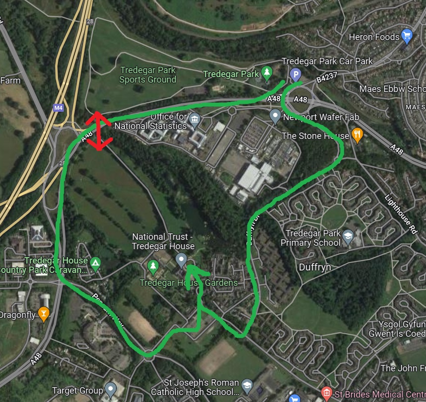
Take a walk in a broadly southerly direction through the park, maybe via a detour to the top of the hillfort (lots of trees so the location of the actual top is not particularly clear) along the recently-upgraded path and you will find yourself quite near, as the crow flies anyway, to Tredegar Park. So you'll be wanting, I would imagine, to continue your pleasant walk in that direction. Well, I've got some bad news for you, bucko, because there are some insurmountable obstacles in your way, specifically the River Ebbw and a railway line. If you want to continue to Tredegar Park then you'll have to follow the path round to where it ends at the gate at the end of Wells Close, find your way to the footbridge over the railway and then follow the roads round through the main car park and into the park. That's the green line on the map; the two red lines show imaginary crossings which would obviously be much better but would require some quite substantial engineering to bridge both railway and river. The only saving grace with the railway is that it isn't the South Wales main line (that takes a more southerly route to get to Cardiff and points west) but the more minor branch line to Ebbw Vale, calling at (among other places) Pye Corner as mentioned here.

Let's assume you've now made the long trek round and have enjoyed all the various delights Tredegar Park has to offer - some outdoor gym equipment, football pitches, a playground, some pleasant riverbank areas - and fancy completing your journey by visiting Tredegar House and its pleasant grounds. Well, strap yourself in for a connecting journey of even more unimaginable complexity and inconvenience, as you'll need to exit via the car park and take one of two possible on-road routes to get round to the only available access points on the south side of the house. How much more convenient it would be, you might think, if one could simply traverse the busy lower reaches of the A48 as it approaches junction 28, where the two parks are probably a hundred yards apart, at most. I mean, you would need a footbridge to avoid being messily dispatched by an HGV, or possibly an underpass to avoid having to thread a footbridge around the ornate (and now unused) pair of gates that face the road at this point.
How utterly marvellous to be able to get on your bike up around Risca Road (in the vicinity of our new house, for instance) and cycle in traffic-free bliss all the way down to Tredegar House; yes, maybe a couple of points where you might have to dismount to traverse a bridge but, really, tish and pshaw to that, certainly in comparison with the current situation. So come on, Newport City Council, how about a bit of joined-up thinking?
No comments:
Post a Comment