Further to the international border talk in the previous post, go back to the start and zoom in on the map in the original tweet and you'll see some oddities. Here (see below), for example. What are those little bits that seem to have dropped off Tajikistan (T) and Uzbekistan (U) and landed in Kyrgyzstan (K)? And indeed the little splinter a bit further north that seems to have peeled off Tajikistan and ended up in Uzbekistan?
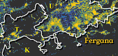
Moreover there's a sort of unspoken assumption - unspoken because it's almost too obvious to need stating explicitly - that countries are internally "connected" in some way, i.e. that if you pick any two random points in a country there'd be a route between them, however circuitous, which didn't require you to cross a border and enter another country. It turns out that this is not true, though, and that if you zoom in on some areas of the map the picture isn't just the same, only bigger, but far more complex than you could have imagined. Take the examples above: the blobs on the map are various exclaves of Tajikistan and Uzbekistan including Sokh and Vorukh.
Weeeeell, you'll be saying, those crazy vodka-fuelled, horse-rectum-crazed ex-Soviets had all sorts of weird habits; we urbane western Europeans would never get involved with that sort of nonsense. Well THINK AGAIN suckers, because let me introduce you to a little place called SPAIN that you might have heard of. Hold on there, bucko, you'll be saying, I know where Spain is: big squarish country occupying most of the Iberian Peninsula. Well let me BLOW YOUR MIND by revealing that some of Spain is wholly in France, and even more bizarrely some of it is on the north coast of Africa. It's not just the Spanish who are at it, though: there are bits of Germany in Belgium and Switzerland, bits of Italy in Switzerland, and most bizarrely of all the absolute insanity of the situation in Baarle-Hertog and Baarle-Nassau and their division between the Netherlands and Belgium. The only thing that might have out-bonkersed it would have been the scattered confetti of a couple of hundred exclaves on the India-Bangladesh border, but sanity prevailed and they were all (well, all but one) swapped back to being in their surrounding country in 2015. Which is a shame, in a way, because they included the only third-order enclave in the world (a piece of India within Bangladesh within India within Bangladesh). You'll have to content yourself with third-order lake islands instead.
All of this largely comes about because while drawing borders on a map is pretty easy, things get a lot more complicated on the ground at 1:1 scale when you involve real people and real immovable bits of landscape. Even the really simple stuff that's probably cropped up in one of your lockdown Zoom quizzes like Colorado and Wyoming being the only two perfectly rectangular US states turns out not to be true - it turns out that thanks to various surveying cock-ups and some inconvenient mountain terrain Colorado is actually a hexahectaenneacontakaiheptagon. Put that in your next Zoom quiz.
No comments:
Post a Comment