Other weather forecasting methods are available, though, and the BBC Weather website actually reckoned that the place we were heading for would be relatively rain-free on Saturday. Additionally there is Dave's Rule Of Weather Forecasting, which has two parts, as follows:
- Chances are tomorrow's weather will be very much like today's;
- If you want to know what the weather will be like the day after tomorrow, wait until tomorrow and then apply rule 1.
Anyway, I can ruin the suspense for you now by revealing that, a bit of initial drizzle and a couple of brief squally showers aside it was shorts and T-shirts weather most of the day. Not a hailstone in sight, not even a little one.
This is the latest in a series of walks that has previously taken in a number of routes in the Gloucestershire area, as well as a couple in Wales. We decided for this one that we'd head over towards the western Brecon Beacons and have a tour of the Ystradfellte waterfalls. Basically these are sandwiched between the main peaks of Pen y Fan and its neighbours and the more remote Black Mountain (venue for my stag weekend in May 2011), about an hour's drive from Newport.
No great elevation involved - highest point is a smidgen under 300 metres - but a bit of up and down and some scrambling, particularly in the vicinity of the waterfalls, of which there are many: Sgwd Gwladus, Sgwd Clun-gwyn and Sgwd yr Eira being the most impressive of the ones we saw. Sgwd yr Eira is particularly noteworthy for having a path running across the rock face behind the waterfall which the intrepid walker can take if he or she doesn't mind getting a bit wet.
There's a fair amount of variation in the amount of water coming over the various waterfalls, depending on how much rain has fallen on the hills above the falls in the past few weeks. I'd say they were reasonably full but not exceptional yesterday, somewhere between the bare trickle they get reduced to in the summer and the raging torrents they become after persistent heavy rain. Compare for instance the picture of Sgwd Gwladus (the first picture) here, and the one here, and note the before and after pictures of Sgwd yr Eira here.
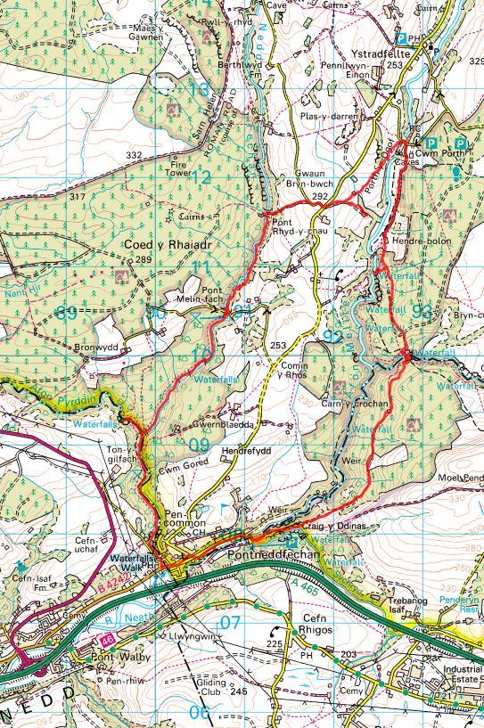
Here's the route map - if you can't get it to display big enough, try this one. We parked in the Dinas Rock car park in Pontneddfechan and did a clockwise circuit from there.

The GPS tracking info (from which that map is drawn) reckons the round trip was 10.8 miles, more than enough distance to justify stopping off for a cheeky pint of Rhymney Bitter in the Angel in Pontneddfechan before heading home. As always there are some photos, here. To augment the photos, Robin captured a couple of brief snippets of video footage in the vicinity of Sgwd Gwladus and behind Sgwd yr Eira.
No comments:
Post a Comment